


Arches National Park, one of Utah’s Mighty Five, has the densest concentration of natural stone arches in the world. It clocks in at over 2,000! With so many arches (but to be fair, that number includes superrrr thin cracks as well), how do you find the best hike in the park?!
Arches became a national park in 1971 after first being named a national monument. While it is most famous for the Entrada Sandstone arches, there are other stunning geologic features including balanced rocks, pinnacles, and fins. Not only is Arches a hikers paradise, but you can also enjoy mountain biking, rock climbing, and camping. The most famous and most photographed spot in the park is Delicate Arch. (Okay, I’m not sure if that is a 100% accurate fact buttttt based on the number of people on that trail PLUS that it is the background on the state of Utah’s license plate probably means it is true right?!). Of course, I recommend hitting up that hike, but the best hike in Arches National Park? Devils Garden Loop.

Devils Garden Loop
distance: 8.1 miles (loop) | elevation: 1,204’ | difficulty: moderate
First things first. If you get vertigo, this hike is probably not for you. Scared of heights (hi, that’s me)? Take caution. Don’t feel completely comfortable navigating the desert backcountry? Maybe bring along a more seasoned friend or don’t complete the entire loop. Not up for rock scrambling? Again, not the hike for you. All sounds good? Perfect, keep reading about the best hike in Arches National Park.
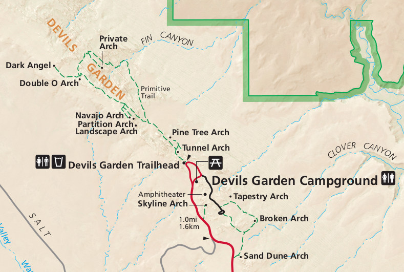
The Devils Garden Loop is the longest maintained trail in the park which includes seven arches and the monolithic Dark Angel. The trail begins on a paved trail, but soon you’ll be surrounded by stunning and interesting rock formations and walking across rock fins.
tunnel arch & pine tree arch

After parking at the Devils Garden parking lot (heads up, this is at the veryyyy far end of the park so it will take some time to drive through the park), head to the trailhead and begin your hike on the well-defined trail. After less than a half a mile, you’ll see a small spur off to the right leading to Tunnel Arch and Pine Tree Arch. I waited till the end of my hike to hit these, but if you got to the trailhead earlier enough, I’d maybe hit them first.
landscape arch

After you head back up to the main paved path, the first arch you’ll come to if you continue clockwise is Landscape Arch. (I recommend clockwise, but if you decide counterclockwise, you’ll see the intersection with the Primitive Trail slightly before this point). This is probably the arch most people are trekking to see – and for good reason! Landscape Arch, at 290 feet, comes in hot at the fifth longest arch in the world (the other four are located in China)! Get yo booty here ASAP because it is thought it may crumble at some point in the not-so-distant-futre as large pieces have continued to break off.
partition arch & navajo arch


From this point, the crowded will greatly diminish. To continue, you’ll scramble up a slot that was once the home to Wall Arch, which collapsed in 2008. You’ll then come to the spur for Partition Arch and Navajo Arch. Don’t skip these! Navajo Arch was a personal favorite of mine! Hidden in a small, hidden alcove… it just had this secluded feel to it (may or may not also have to do with the fact that I was the only one there as well…).
Head back to the main trail and this is the really the section where you’ll have to walk on rock fins. Reading about this before I went I was slightly terrified… but for someone who is scared of heights, it was not as bad as I was imagining! The “trail” is wider than I thought (easy to pass people coming the opposite way) andddd I just didn’t look down! Because yeah, there are some massive drops on both sides! But this area provides a great place to take some photos which capture the desert landscape plus the impressive La Sal Mountains which loom in the background. This section also provides an overlook to Black Arch.

As this part of the trail is almost entirely rock, it can be a lil tricky to keep track of the path, but just keep your eyes out for rock cairns. On that note, make sure to not kick them over, add cairns, as this tells hikers where to walk, which in turn, protects the park.
the primitive trail
double o arch

You’ll then come to a trail junction of the Primitive Trail, Double O Arch, and Dark Angel. Take the faint path which leads to the Double O Arch. Once you make it to the arch, it is not really too difficult to see where this arch got its name. This is the second largest arch you’ll see in Devils Garden. To get a better view of the two arches, plus a sweet desert landscape through them, climb through the bottom arch and walk up the slope.
dark angel

If you’re opting to head to Dark Angel (which umm, you should!), head back through the arch towards the junction. Dark Angel is not an arch like everything else you’ve seen thus far, but instead a 150 foot tall monolith. You can take in some great views of the Klondike Bluffs and Salt Valley here. Follow your steps back through the plateau to the Primitive Trail junction to continue on the loop.
private arch

The Primitive Trail is gorgeous, remote, and definitely feels secluded. Like before, look out for rock cairns to stay on the trail as it is sometimes hard to navigate and make sure to continue drinking water – sometimes it is hard to judge how dehydrated you are in the dry heat. On the Primitive Trail, you’ll also be walking on A LOT of sand, so know it takes a little longer than usual. In less than half a mile from the junction, you’ll come to the Private Arch Trail. Again, the best views of this arch come by scrambling up a rock fin.
On that note, please please please don’t climb on top of the arches in the park. It seems obvious and of course, there are signs prohibiting it, but just don’t!

Heading back to the Primitive Trail, you have about two and a half miles to get back to the trailhead. The trail consists of a lot of sand, some rock scaling, and washes. Okay, guys, at this point, I thought since I had accomplished the rock fins and the scary part was done. Not quiteeeee. I come across some rock fins… seem a little scary so I decided to just scoot on down on my booty. Then it comes… this SANDY rock fin where you have to scale about a 12 foot skinny section to a huge dropoff! I honestly was thinking I may as well turn around at this point because there was nothing to hold onto and I had no clue what to do. Luckily, there was a couple in front of me that had witnessed me scooting down on my booty and hiked back to check on me (hikers are the friendliest people, amirite?!). With some coaxing and a hand… I made it! (Nevermind, the cramp I had in my thigh for like three days due to the uncontrolled shaking…).
But before ya know it, you’re back to crowds of people near Landscape Arch. If you didn’t make it to Tunnel Arch and Pine Tree Arch on your way in, hit those up. Otherwise, head back to your car… you just finished the best hike in Arches National Park!
Pro tip: keep some (light blue) Gatorade in a cooler for a nice treat after those eight miles!

know before ya go to devils garden loop
- y’all, this hike can be CROWDED – you’ll want to hit this as early as possible (in part due to the heat as well!).
- as a side note, the parking lot can be deceiving however because many are just taking the hike up to see Landscape Arch (the largest arch in Arches National Park and the fifth largest in the world according to the Natural Bridge and Arch Society – did ya know there was such a thing?!) and then turning around to head back to their car.
- you’re in the desert which means you can’t forget the two essentials – water and sun protection! The Devils Garden Loop is over seven miles… you may not feel thirsty in the dry desert climate, but you need to be drinking A LOT. Also, there is almost no shade on this hike, so be prepared with sunscreen, hats, clothing, etc.
- this hike is SANDY. For this reason, I’d suggest low top hiking shoes (while I saw a couple of people in vans, that’s not exactly what I’m referring to) with good grip.
- the Primitive Trail can be difficult to follow – keep this in mind if you’re not comfortable navigating in the backcountry.
- you will be walking on rock fins, sometimes with big dropoffs… just a little thing to know if you’re terrified of heights (as I mentioned, I’m scared of heights and (besides one little part) I made it through without too much fear.
- I’d recommend doing the loop clockwise as I think the rock scrambling would be easier in this direction.
- no pups allowed sadly (on any hike in Arches National Park).


